Trail Snowshoes La Clusaz - La Pointe de Beauregard - FR - Photo

La Pointe de Beauregard - FR

 UDGI54
UDGI54

User

© OpenStreetMap contributors
Length
Length
12.2 km
Max alt
Max alt
1633 m
Uphill gradient
Uphill gradient
673 m
Km-Effort
Km-Effort  
21 km
Min alt
Min alt
1046 m
Downhill gradient
Downhill gradient
671 m
Boucle
Boucle
Yes
Creation date :
2021-12-13 17:28:53.986
Updated on :
2021-12-13 17:30:25.316

(0 Reviews)

Snowshoes
Snowshoes
--
Difficulty : Very easy

Scan this QR Code to open this trail in the SityTrail application

FREE GPS app for hiking

Logo SityTrail SityTrail

IGN / Geographical institutes

Download SityTrail from the App Store Download SityTrail from Google Play

Logo SityTrail SityTrail World

The world is yours!

Download SityTrail from the App Store Download SityTrail from Google Play Download SityTrail on Huawei AppGallery

About

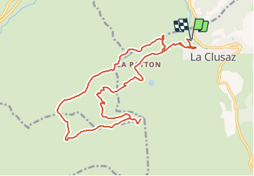
Trail Snowshoes of 12.2 km to be discovered at Auvergne-Rhône-Alpes, Upper Savoy, La Clusaz. This trail is proposed by UDGI54.

Description

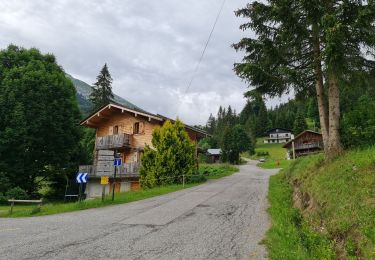
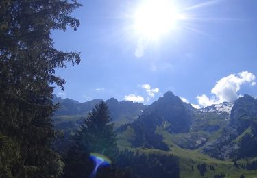
Randonnée assez sportive à la pointe de Beauregard offrant de nombreux panoramas sur la chaîne des Aravis et sur le massif des Bornes. Cet itinéraire alterne ambiance forestière et alpages. Montée en lacets pour ensuite cheminer sur un relief plus doux sur le plateau. Au sommet, la restauration est possible dans plusieurs chalets d'altitude.

Départ : La Clusaz, parking du Salon des Dames

Elevation profile

Points of interest

Point of interest La Clusaz - Poursuivre sur le chemin - Photo
UDGI54
Point of interest La Clusaz - Prendre à gauche - Photo
UDGI54
Point of interest Les Villards-sur-Thônes - Les Corbassières (ferme), tourner à gauche et passer devant la ferme - Photo
UDGI54
LES VILLARDS-SUR-THÔNES 
Point of interest Les Villards-sur-Thônes - Poursuivre sur le sentier montant à gauche - Photo
UDGI54
LES VILLARDS-SUR-THÔNES 
Point of interest Les Villards-sur-Thônes - Sous Beauregard altitude 1545 m, prendre le chemin de gauche - Photo
UDGI54
LES VILLARDS-SUR-THÔNES 
Point of interest Les Villards-sur-Thônes - Plateau de Beauregard (Auberge) altitude 1610 m, faire un aller retour au panorama à la Pointe de Beauregard en prenant à gauche direction Pointe de Beauregard - Photo
UDGI54
LES VILLARDS-SUR-THÔNES 
Point of interest Les Villards-sur-Thônes - Table d'orientation Sommet Télécabine Beauregard - Photo
UDGI54
LES VILLARDS-SUR-THÔNES 
Point of interest Les Villards-sur-Thônes - Panorama sur la chaîne des Aravis et le massif du Mont Blanc - Photo
UDGI54
LES VILLARDS-SUR-THÔNES 
Point of interest Les Villards-sur-Thônes - Plateau de Beauregard (Auberge) altitude 1610 m, prendre à gauche direction Croix de Colomban - Photo
UDGI54
LES VILLARDS-SUR-THÔNES 
Point of interest Les Villards-sur-Thônes - La Siesta altitude 1615 m, prendre le chemin montant à droite direction Croix de Colomban - Photo
UDGI54
LES VILLARDS-SUR-THÔNES 
Point of interest Les Villards-sur-Thônes - Les Vaunessins altitude 1610 m, prendre la piste de droite direction Les Poutassets - Photo
UDGI54
LES VILLARDS-SUR-THÔNES 
Point of interest Thônes - Poursuivre tout droit - Photo
UDGI54
Point of interest Les Villards-sur-Thônes - Le Vargne altitude 1565 m, passer à gauche du chalet puis prendre à droite le sentier - Photo
UDGI54
LES VILLARDS-SUR-THÔNES 
Point of interest Les Villards-sur-Thônes - Les Corbassières altitude 1510 m, prendre à gauche le sentier direction Parmis Est - Photo
UDGI54
LES VILLARDS-SUR-THÔNES 
Point of interest Les Villards-sur-Thônes - Parmis (Est) altitude 1430 m, prendre à droite le sentier direction Les Ecotagnes (Sud) - Photo
UDGI54
LES VILLARDS-SUR-THÔNES 
Point of interest Saint-Jean-de-Sixt - Prendre le sentier à droite direction La Patton - Photo
UDGI54
Point of interest Saint-Jean-de-Sixt - Bois de l'Ars altitude 1384 m, descendre à droite par le sentier en lacets direction Les Riffroids - Photo
UDGI54
SAINT-JEAN-DE-SIXT 
Point of interest La Clusaz - Tourner à gauche - Photo
UDGI54

Positioning

Country:
France
Region :
Auvergne-Rhône-Alpes
Department/Province :
Upper Savoy
Municipality :
La Clusaz
Location:
Unknown
Start:(UTM)
299784 ; 5086952 (32T) N.

Trails nearby

Trail Snowshoes Manigod - croix de colonban croix de fry - Photo
Snowshoes
myjackotte

Snowshoes

Medium
(3)
Manigod, Auvergne-Rhône-Alpes, Upper Savoy, France
8 km | 11.6 km-effort
3h 5min
Yes
Trail Mountain bike Le Grand-Bornand - vtt-dans-la-vallee-du-bouchet - Photo
Mountain bike
GUIDE
pascalou73

Mountain bike

Very easy
Le Grand-Bornand, Auvergne-Rhône-Alpes, Upper Savoy, France
7.5 km | 10.5 km-effort
Unknown
No
Trail Mountain bike Le Grand-Bornand - VTT du grand bornand au refuge - Photo
Mountain bike
GUIDE
pascalou73

Mountain bike

Very easy
Le Grand-Bornand, Auvergne-Rhône-Alpes, Upper Savoy, France
25 km | 38 km-effort
Unknown
Yes
Trail Mountain bike Le Grand-Bornand - Le_Grand_Bornand_20210706_104522 - Photo
Mountain bike
GUIDE
pascalou73

Mountain bike

Very easy
Le Grand-Bornand, Auvergne-Rhône-Alpes, Upper Savoy, France
18.4 km | 29 km-effort
Unknown
Yes
Trail Walking La Clusaz - Les Converses, Le Planet, Beauregard, les Corbassières (boucle) - Photo
Walking
GUIDE
lhomme.ph

Walking

Difficult
La Clusaz, Auvergne-Rhône-Alpes, Upper Savoy, France
10.4 km | 17.7 km-effort
3h 11min
Yes
Trail Mountain bike Le Grand-Bornand - Le_Grand_Bornand_20200623_090207 - Photo
Mountain bike
GUIDE
pascalou73

Mountain bike

Very easy
Le Grand-Bornand, Auvergne-Rhône-Alpes, Upper Savoy, France
26 km | 38 km-effort
Unknown
No
Trail Snowshoes La Clusaz - col aravis - Photo
Snowshoes
myjackotte

Snowshoes

Easy
(2)
La Clusaz, Auvergne-Rhône-Alpes, Upper Savoy, France
5.7 km | 8.2 km-effort
2h 16min
Yes
Trail Snowshoes Thônes - Mlande Platenet Frassot  Mlande - Photo
Snowshoes
thierryd

Snowshoes

Very easy
(1)
Thônes, Auvergne-Rhône-Alpes, Upper Savoy, France
7.3 km | 13.7 km-effort
3h 24min
Yes
Trail Mountain bike La Clusaz - VTT Aravis  - Photo
Mountain bike
Tibo74lc

Mountain bike

Medium
(1)
La Clusaz, Auvergne-Rhône-Alpes, Upper Savoy, France
35 km | 52 km-effort
2h 38min
Yes


Close
My subscriptions